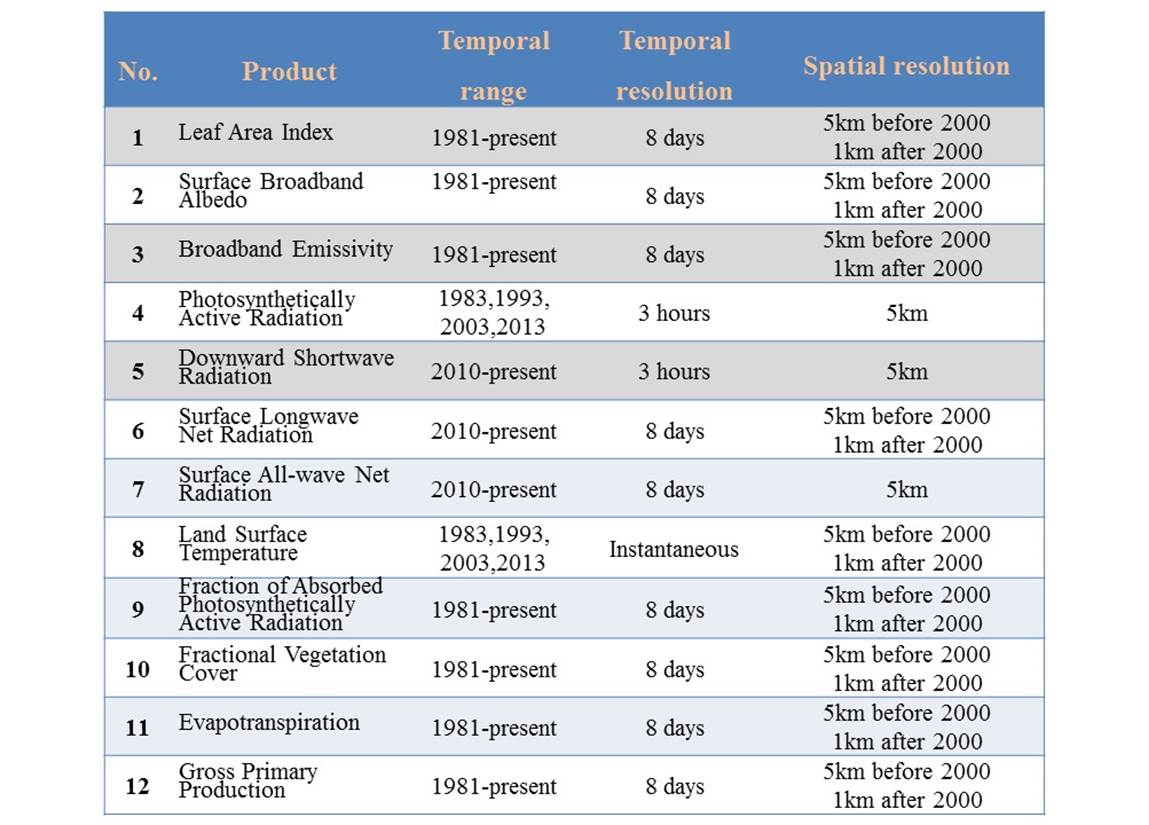
The Global LAnd
Surface Satellite (GLASS) products
1. Introduction
The
GLASS product suite initially included 5 products (Liang et al. 2013a; Liang et al. 2013b), but has been
recently expanded into 12 products, such as leaf area index, broadband albedo,
broadband longwave emissivity, downward shortwave radiation and photosynthetically active radiation, land surface temperature,
longwave net radiation, daytime all-wave net radiation, fraction of absorbed photosynetically active radiation absorbed by green
vegetation, fraction of vegetation cover, gross primary productivity, and
evapotranspiration. Their characteristics are summarized in the following
table. Note these products are being continuously updated.
The
GLASS products have some unique features, for example,
· many
of these products span about 35 years from 1981-present, highly suitable for
long-term environmental change studies;
· the
radiation products have the spatial resolution of 5km, much finer than the
commonly used products (e.g., CERES, GEWEX);
· all
products are spatially and temporally continuous with no gaps and missing
values;
· The
broadband longwave emissivity product is the first product of this kind in the
world at 8-day temporal resolution and 1km spatial resolution; and
· the
GLASS products have been demonstrated to have high accuracies.
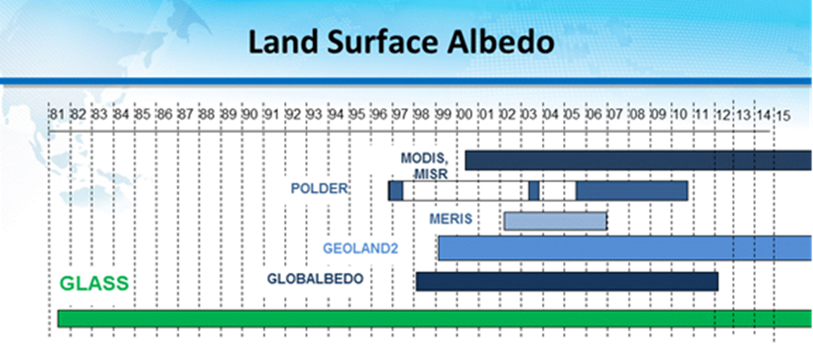
As
one example, figure 1 shows that the GLASS albedo product has the longest
temporal coverage compared with other existing global albedo products.
Efforts
are being made to generate 15 land Climate Data Records (CDRs) and other 20
land products (Liang et al. 2016).
2. Product descriptions
1). LAI
It
has two versions: GLASS-MODIS LAI and GLASS-AVHRR LAI. The GLASS-MODIS LAI
product is generated using the general regression neural networks (GRNNs)(Xiao et al. 2014), and the GLASS-AVHRR LAI product is generated
using the same GRNN algorithm (Xiao et al. 2016a) from the
re-processed Long-Term Data Record (LTDR) AVHRR data for over 35 years(Xiao et al. 2017; Xiao et al. 2015b).
The
GLASS LAI product has been widely used, for example, verifying the Earth system
model simulation accuracy (Bao et al. 2014),evaluating
the vegetation responses to climate change in the arid and semi-arid region (Jiapaer et al. 2015),computing
GPP and ET (Liu et al. 2015; Tian et al. 2015), FAPAR (Xiao et al. 2015a) and FVC (Xiao et al. 2016b), assessing
hydrological simulations (Tesemma et al. 2015),determining
overestimation of forest GPP(Ma et al. 2015),and
monitoring the greening trends over China (Piao et al. 2015) and globe (Zhu et al. 2016).
2). FAPAR
The
GLASS FAPAR product is calculated from the GLASS LAI product and other
information (Xiao et al. 2015a), so it shares the
similar characteristics to the GLASS LAI products, and these two products are
physically consistent.
3). Fraction of vegetation cover (FVC)
The
GLASS FVC product is generated using a machine learning technique (Jia et al. 2015).
4). Incident shortwave radiation
The
GLASS MODIS shortwave radiation product is based on conversion of shortwave net
radiation and land surface albedo, and the GLASS-AVHRR shortwave radiation is
estimated from the refined look-up table (LUT) method (Zhang et al. 2014). Its spatial
resolution (5km) is significantly higher than other global products with the
spatial resolutions coarser than 1°.
5). Incident PAR
The
GLASS PAR product is produced from the GLASS shortwave radiation product as
well as the LUT method (Liang et al. 2006). Its
spatial resolution (5km) is significantly higher than other global products
with the spatial resolutions coarser than 1°. Cai et
al. (2014) demonstrated that
the input of GLASS PAR product with better accuracy can result in the improved
calculation of GPP.
6). Broadband albedo
The
GLASS albedo product includes shortwave, visible and near-IR broadband albedo.
It is an integration (Liu et al. 2013a; Liu et al. 2013b) of two
intermediate products estimated from surface reflectance and top-of-atmosphere
(TOA) reflectance (Qu et al. 2014) using the “direct
estimation algorithm” (Liang 2003; Liang et al. 1999; Liang et al. 2005), which is different from the
conventional methods consisting of atmospheric correction, BRDF modeling,
narrowband to broadband conversion (Schaaf et al. 2002).
The
GLASS albedo has been used for assessing the Greenland albedo dependence on the
climate change (He et al. 2013), determining the global
albedo climatology (He et al. 2014), and computing
the radiative forcing due to snow cover changes (Chen et al. 2016a; Chen et al. 2016b; Chen et al.
2015; Chen et al. 2017) and forest disturbances (Zhang and Liang 2014).
7). LST
The
GLASS LST product is generated using the split-window approach (Zhou et al. 2014) based on
extensive radiative transfer simulations(Huang et al. 2016).
8). Broadband emissivity
The
GLASS longwave broadband emissivity product is based on conversion of shortwave
spectral albedos for soils (Cheng and Liang 2013a; Cheng and Liang 2013b; Cheng
et al. 2011) and radiative transfer calculations
for vegetation (Cheng et al. 2016). The ocean
emissivity product will be also produced(Cheng et al. 2017a).
9). Longwave net radiation
Downward
and upwelling longwave radiation are estimated separately. Upwelling longwave
radiation can be calculated from LST and broadband longwave emissivity, but the
uncertainties of these two components may cause large errors (Wang and Liang 2009). The direct
estimation methods have been developed for estimating upwelling, downward and
net longwave radiation (Cheng and Liang 2016; Cheng et al. 2017b).
10).
All-wave day-time net radiation
Instead
of adding all components whose uncertainties may be accumulated, the GLASS net
radiation product is based on conversion of shortwave net radiation in
conjunction with other information. After comparing different linear formulae (Jiang et al. 2015) and machine
learning techniques (Jiang et al. 2014), The MARS
algorithm is used for producing the global day-time all-wave net radiation (Jiang et al. 2016). The validation
and comparisons with other products are also carried out (Jia et al. 2016; Jia et al. 2017). Its spatial
resolution (5km) is significantly higher than other global products with the
spatial resolutions coarser than 1°.
11).
ET
The
GLASS ET product is generated by merging five process-based algorithms using
the Bayesian model averaging (BMA) method(Yao et al. 2014). The five algorithms include the
MODIS ET product algorithm, the revisedremote-sensing-based
Penman-Monteith ET algorithm, the Priestley-Taylor-based
ET algorithm, the modified satellite-based Priestley-Taylor ET algorithm, and
the semi-empirical Penman ET algorithm. The validation results demonstrated
that the integrated product is more accurate than any individual algorithm
estimate.
12). GPP
The
GLASS GPP product is also using the BMA to integrate the estimates from 8 light
use efficiency models. The EC-LUE (Eddy Covariance- Light Use Efficiency) model
is one of them developed by the GLASS GPP developer (Yuan et al. 2007; Yuan et al. 2010).
3.
Product distribution
The
GLASS products are being distributed through the Data Center for Global Change
Processing and Analysis at Beijing Normal University (http://www.bnu-datacenter.com/) and
the
Global Land Cover Facility at the University of Maryland (www.landcover.org).
4. References
Bao, Y., Gao, Y.H., Lu, S.H., Wang, Q.X.,
Zhang, S.B., Xu, J.W., Li, R.Q., Li, S.S., Ma, D., Meng, X.H., Chen, H., &
Chang, Y. (2014). Evaluation of CMIP5 Earth System Models in Reproducing Leaf
Area Index and Vegetation Cover over the Tibetan Plateau. Journal of Meteorological Research, 28, 1041-1060
Cai, W., Yuan, W., Liang, S., Zhang, X., Dong, W.,
Xia, J., Fu, Y., Chen, Y., Liu, D., & Zhang, Q. (2014). Improved
estimations of gross primary production using satellite-derived
photosynthetically active radiation. Journal
of Geophysical Research: Biogeosciences, 119, 2013JG002456
Chen, X., Liang, S., & Cao, Y. (2016a). Satellite
observed changes in the Northern Hemisphere snow cover phenology and the
associated radiative forcing and feedback between 1982 and 2013. Environmental Research Letters, 11,
084002
Chen, X., Liang, S., Cao, Y., & He, T. (2016b).
Distribution, attribution, and radiative forcing of snow cover changes over
China from 1982 to 2013. Climatic Change,
137, 363-377
Chen, X., Liang, S., Cao, Y., He, T., & Wang, D.
(2015). Observed contrast changes in snow cover phenology in northern middle
and high latitudes from 2001–2014. Scientific
Reports, 5, 16820
Chen, X., Long, D., Hong, Y., Liang, S., & Hou, A.
(2017). Observed radiative cooling over the Tibetan Plateau for the past three
decades driven by snow cover induced surface albedo anomaly. Journal of Geophysical Research:
Atmospheres, 122, 6170-6185
Cheng, J., Cheng, X., Liang, S., Niclòs, R., Nie, A.,
& Liu, Q. (2017a). A Lookup Table-Based Method for Estimating Sea Surface
Hemispherical Broadband Emissivity Values (8–13.5 μm). Remote Sensing, 9, 245,doi:210.3390/rs9030245
Cheng, J., & Liang, S. (2013a). Estimating global
land surface broadband thermal-infrared emissivity from the Advanced Very High
Resolution Radiometer optical data. International
Journal of Digital Earth, DOI: 10.1080/17538947.17532013.17783129
Cheng, J., & Liang , S. (2013b). A Novel Algorithm
for Estimating Broadband Emissivity of Global Bare Soil using MODIS Albedo
Product. IEEE Transactions on Geoscience
and Remote Sensing, 51, 2619-2631
Cheng, J., & Liang, S. (2016). Global Estimates
for High-Spatial-Resolution Clear-Sky Land Surface Upwelling Longwave Radiation
From MODIS Data. IEEE Transactions on
Geoscience and Remote Sensing, 54, 4115-4129
Cheng, J., Liang, S., Tzeng, Y.C., Wang, C., &
Rebn, H. (2011). Mapping global broadband emissivity from MODIS albedo product
by using dynamic learning neural network. IEEE
Transactions on Geoscience and Remote Sensing, submitted
Cheng, J., Liang, S., Verhoef, W., Shi, L., & Liu,
Q. (2016). Estimating the Hemispherical Broadband Longwave Emissivity of Global
Vegetated Surfaces Using a Radiative Transfer Model. IEEE Transactions on Geoscience and Remote Sensing, 54, 905-917
Cheng, J., Liang, S., Wang, W., & Guo, Y. (2017b).
An efficient hybrid method for estimating clear‐sky surface downward
longwave radiation from MODIS data. Journal
of Geophysical Research: Atmospheres, 122, doi:10.1002/2016JD026250
He, T., Liang, S., & Song, D.-X. (2014). Analysis
of global land surface albedo climatology and spatial-temporal variation during
1981–2010 from multiple satellite products. Journal
of Geophysical Research: Atmospheres, 119, 10,281-210,298
He, T., Liang, S., Yu, Y., Liu, Q., & Gao, F. (2013).
Greenland surface albedo changes 1981-2012 from satellite observations. Environmental Research Letters, 8,
044043, DOI:044010.041088/041748-049326/044048/044044/044043
Huang, F., Zhou, J., Tao, J., Tan, X., Liang, S.,
& Cheng, J. (2016). Pmodtran: A parallel implementation based on modtran
for massive remote sensing data processing. International
Journal of Digital Earth, 9, 819-834
Jia, A., Jiang, B., Liang, S., Zhang, X., & Ma, H.
(2016). Validation and Spatiotemporal Analysis of CERES Surface Net Radiation
Product. Remote Sensing, 8, 90
Jia, A., Liang, S., Jiang, B., Zhang, X., & Wang,
G. (2017). Uncertainty analysis of the surface net radiation products from
in-situ, satellite and reanalysis data. Journal of Geophysical Research,
submitted
Jia, K., Liang, S., Liu, S.H., Li, Y.W., Xiao, Z.Q.,
Yao, Y.J., Jiang, B., Zhao, X., Wang, X.X., Xu, S., & Cui, J. (2015).
Global Land Surface Fractional Vegetation Cover Estimation Using General
Regression Neural Networks From MODIS Surface Reflectance. IEEE Transactions on Geoscience and Remote Sensing, 53, 4787-4796
Jiang, B., Liang, S., Ma, H., Zhang, X., Xiao, Z.,
Zhao, X., Jia, K., Yao, Y., & Jia, A. (2016). GLASS Daytime All-Wave Net
Radiation Product: Algorithm Development and Preliminary Validation. Remote Sensing, 8, 222
Jiang, B., Zhang, Y., Liang, S., Wohlfahrt, G., Arain,
A., Cescatti, A., Georgiadis, T., Jia, K., Kiely, G., Lund, M., Montagnani, L.,
Magliulo, V., Ortiz, P.S., Oechel, W., Vaccari, F.P., Yao, Y., & Zhang, X.
(2015). Empirical estimation of daytime net radiation from shortwave radiation
and ancillary information. Agricultural
and Forest Meteorology, 211–212, 23-36
Jiang, B., Zhang, Y., Liang, S., Zhang, X., &
Xiao, Z. (2014). Surface Daytime Net Radiation Estimation Using Artificial
Neural Networks. Remote Sensing, 6,
11031-11050
Jiapaer, G., Liang, S., Yi, Q.X., & Liu, J.P.
(2015). Vegetation dynamics and responses to recent climate change in Xinjiang
using leaf area index as an indicator. Ecological
Indicators, 58, 64-76
Liang, S. (2003). A direct algorithm for estimating
land surface broadband albedos from MODIS imagery. IEEE Transactions on Geoscience and Remote Sensing, 41, 136-145
Liang, S., Strahler, A., & Walthall, C. (1999).
Retrieval of land surface albedo from satellite observations: A simulation
study. Journal of Applied Meteorology, 38,
712-725
Liang, S., Stroeve, J., & Box, J.E. (2005).
Mapping daily snow/ice shortwave broadband albedo from Moderate Resolution
Imaging Spectroradiometer (MODIS): The improved direct retrieval algorithm and
validation with Greenland in situ
measurement. Journal of Geophysical
Research-Atmospheres, 110, Art. No. D10109
Liang, S., Tang, S., Zhang, J., Xu, B., Cheng, J.,
Cheng, X., Gong, P., Jia, K., Jiang, B., Li, A., Liu, S., Qiu, H., Xiao, Z.,
Xie, X., Yang, J., Yang, J., Yao, Y., Yu, G., Zhang, X., & Zhao, X. (2016).
Global Climate Data Revords generation and applications to climate change
studies. Journal of Remote Sensing, 20,
1491-1499
Liang, S., Zhang, X., Xiao, Z., Cheng, J., Liu, Q.,
& Zhao, X. (2013a). Global LAnd
Surface Satellite (GLASS) products: Algorithms, validation and analysis.
Springer
Liang, S., Zhao, X., Yuan, W., Liu, S., Cheng, X.,
Xiao, Z., Zhang, X., Liu, Q., Cheng, J., Tang, H., Qu, Y.H., Bo, Y., Qu, Y.,
Ren, H., Yu, K., & Townshend, J. (2013b). A Long-term Global LAnd Surface
Satellite (GLASS) Dataset for Environmental Studies. International Journal of Digital Earth, 6, 5-33
Liang, S., Zheng, T., Liu, R., Fang, H., Tsay, S.C.,
& Running, S. (2006). Mapping incident Photosynthetically Active Radiation
(PAR) from MODIS Data. Journal of
Geophysical Research-Atmospheres, 111, Art. No. D15208,
doi:15210.11029/12005JD006730.
Liu, N., Liu, Q., Wang, L., Liang, S., Wen, J., Qu,
Y., & Liu, S. (2013a). A statistics-based temporal filter algorithm to map
spatiotemporally continuous shortwave albedo from MODIS data. Hydrology and Earth System Sciences, 17,
2121-2129, doi:2110.5194/hess-2117-2121-2013
Liu, Q., Wang, L., Qu, Y., Liu, N., Liu, S., Tang, H.,
& Liang, S. (2013b). Priminary Evaluation of the Long-Term GLASS Albedo
Product. International Journal of Digital
Earth, 6, 69-95,doi:10.1080/17538947.17532013.17804601
Liu, Z.J., Shao, Q.Q., & Liu, J.Y. (2015). The
Performances of MODIS-GPP and -ET Products in China and Their Sensitivity to
Input Data (FPAR/LAI). Remote Sensing, 7,
135-152
Ma, J.Y., Yan, X.D., Dong, W.J., & Chou, J.M.
(2015). Gross primary production of global forest ecosystems has been
overestimated. Scientific Reports, 5,
9
Piao, S.L., Yin, G.D., Tan, J.G., Cheng, L., Huang,
M.T., Li, Y., Liu, R.G., Mao, J.F., Myneni, R.B., Peng, S.S., Poulter, B., Shi,
X.Y., Xiao, Z.Q., Zeng, N., Zeng, Z.Z., & Wang, Y.P. (2015). Detection and
attribution of vegetation greening trend in China over the last 30 years. Global Change Biology, 21, 1601-1609
Qu, Y., Liu, Q., Liang, S., Wang, L., Liu, N., &
Liu, S. (2014). Improved direct-estimation algorithm for mapping daily
land-surface broadband albedo from MODIS data. IEEE Transactions on Geoscience and Remote Sensing, 52, 907-919
Schaaf, C., Gao, F., Strahler, A., Lucht, W., Li, X.,
Tsung, T., Strugll, N., Zhang, X., Jin, Y., Muller, P., Lewis, P., Barnsley,
M., Hobson, P., Disney, M., Roberts, G., Dunderdale, M., Doll, C., d'Entremont,
R., Hu, B., Liang, S., Privette, J., & Roy, D. (2002). First operational
BRDF, albedo nadir reflectance products from MODIS. Remote Sensing of Environment, 83, 135-148
Tesemma, Z.K., Wei, Y., Peel, M.C., & Western,
A.W. (2015). The effect of year-to-year variability of leaf area index on
Variable Infiltration Capacity model performance and simulation of runoff. Advances in Water Resources, 83, 310-322
Tian, X., van der Tol, C., Su, Z.B., Li, Z.Y., Chen,
E.X., Li, X., Yan, M., Chen, X.L., Wang, X.F., Pan, X.D., Ling, F.L., Li, C.M.,
Fan, W.W., & Li, L.H. (2015). Simulation of Forest Evapotranspiration Using
Time-Series Parameterization of the Surface Energy Balance System (SEBS) over
the Qilian Mountains. Remote Sensing, 7,
15822-15843
Wang, K., & Liang, S. (2009). Evaluation of ASTER
and MODIS land surface temperature and emissivity products using surface
longwave radiation observations at SURFRAD sites. Remote Sensing of Environment, 113, 1156-1165
Xiao, Z., Liang, S., Sun, R., Wang, J., & Jiang,
B. (2015a). Estimating the fraction of absorbed photosynthetically active
radiation from the MODIS data based GLASS leaf area index product. Remote Sensing of Environment, 171,
105-117
Xiao, Z., Liang, S., Tian, X., Jia, K., Yao, Y., &
Jiang, B. (2017). Reconstruction of Long-Term Temporally Continuous NDVI and
Surface Reflectance From AVHRR Data. Ieee
Journal of Selected Topics in Applied Earth Observations and Remote Sensing,
DOI:10.1109/JSTARS.2017.2744979
Xiao, Z., Liang, S., Wang, J., & Zhao, X. (2016a).
Long Time Series Global Land Surface Satellite (GLASS) Leaf Area Index Product
Derived from MODIS and AVHRR Surface Reflectance. IEEE Transactions on Geoscience and Remote Sensing,
DOI:10.1109/TGRS.2016.2560522
Xiao, Z., Liang, S., Wang, T., & Liu, Q. (2015b).
Reconstruction of Satellite-Retrieved Land-Surface Reflectance Based on
Temporally-Continuous Vegetation Indices. Remote
Sensing, 7, 9844
Xiao, Z., Wang, T., Liang, S., & Sun, R. (2016b).
Estimating the Fractional Vegetation Cover from GLASS Leaf Area Index Product. Remote Sensing, 8, 337
Xiao, Z.Q., Liang, S., Wang, J.D., Chen, P., Yin,
X.J., Zhang, L.Q., & Song, J.L. (2014). Use of General Regression Neural
Networks for Generating the GLASS Leaf Area Index Product From Time-Series
MODIS Surface Reflectance. IEEE
Transactions on Geoscience and Remote Sensing, 52, 209-223
Yao, Y., Liang, S., Li, X., Hong, Y., Fisher, J.B.,
Zhang, N., Chen, J., Cheng, J., Zhao, S., Zhang, X., Jiang, B., Sun, L., Jia,
K., Wang, K., Chen, Y., Mu, Q., & Feng, F. (2014). Bayesian multimodel
estimation of global terrestrial latent heat flux from eddy covariance,
meteorological, and satellite observations. Journal
of Geophysical Research: Atmospheres, 119, 2013JD020864
Yuan, W.P., Liu, S., Zhou, G.S., Zhou, G.Y., Tieszen,
L.L., Baldocchi, D., Bernhofer, C., Gholz, H., Goldstein, A.H., Goulden, M.L.,
Hollinger, D.Y., Hu, Y., Law, B.E., Stoy, P.C., Vesala, T., Wofsy, S.C., &
AmeriFlux, C. (2007). Deriving a light use efficiency model from eddy
covariance flux data for predicting daily gross primary production across
biomes. Agricultural and Forest
Meteorology, 143, 189-207
Yuan, W.P., Liu, S.G., Yu, G.R., Bonnefond, J.M.,
Chen, J.Q., Davis, K., Desai, A.R., Goldstein, A.H., Gianelle, D., Rossi, F.,
Suyker, A.E., & Verma, S.B. (2010). Global estimates of evapotranspiration
and gross primary production based on MODIS and global meteorology data. Remote Sensing of Environment, 114,
1416-1431
Zhang, X., Liang, S., Zhou, G., Wu, H., & Zhao, X.
(2014). Generating Global LAnd Surface Satellite incident shortwave radiation
and photosynthetically active radiation products from multiple satellite data. Remote Sensing of Environment, 152,
318-332
Zhang, Y., & Liang, S. (2014). Surface radiative
forcing of forest disturbances over northeastern China Environmental Research Letters, 9, 024002,doi:024010.021088/021748-029326/024009/024002/024002
Zhou, J., Zhang, X., Zhan, W., & Zhang, H. (2014).
Land surface temperature retrieval from MODIS data by integrating regression
models and the genetic algorithm in an arid region. Remote Sensing, 6, 5344-5367
Zhu, Z., Piao, S., Myneni, R.B., Huang,
M., Zeng, Z., Canadell, J.G., Ciais, P., Sitch, S., Friedlingstein, P., Arneth,
A., Cao, C., Cheng, L., Kato, E., Koven, C., Li, Y., Lian, X., Liu, Y., Liu,
R., Mao, J., Pan, Y., Peng, S., Penuelas, J., Poulter, B., Pugh, T.A.M.,
Stocker, B.D., Viovy, N., Wang, X., Wang, Y., Xiao, Z., Yang, H., Zaehle, S.,
& Zeng, N. (2016). Greening of the Earth and its drivers. Nature Clim. Change, 6, 791-795