Final Project
Using the ArcGIS API for JavaScript to map "Hazardous Weather Events"
Click Here to view the large version of the map
 The map below can be used to identify various hazardous weather occurrences. Hazardous weather is any weather which poses a threat to
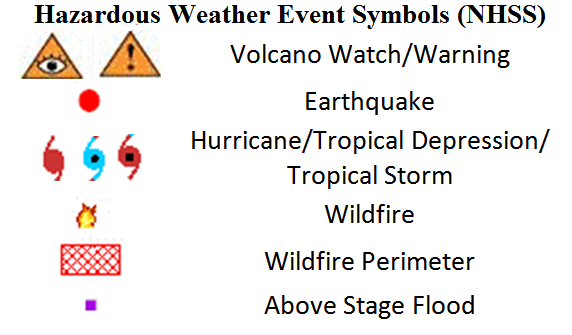
populations in the local area. The National Hazards Support System (NHSS) provides up-to-date information on such events. These weather events are illustrated in the key to the right.
The map below can be used to identify various hazardous weather occurrences. Hazardous weather is any weather which poses a threat to
populations in the local area. The National Hazards Support System (NHSS) provides up-to-date information on such events. These weather events are illustrated in the key to the right. To identify a symbol in the map, check the first box below ("Toggle Identify Hazardous Weather tool").
To create a buffer around a point, check the second box ("Toggle Buffer tool"), enter the distance, in miles, of the desired buffer in the text box, and click on the map.
To search for a city or state and display its population, use the search box at the bottom. Enter the desired search text and submit using the "Search" button. Click on a row in the results table to zoom into that feature.
Toggle Buffer tool, in miles
Find a City or State and Display the Results Below:
| State Name | City Name | Population |
|---|
Data Sources:
NHSS Data Center
NHSS Hazardous Weather Map Server
Esri States, Cities, and Rivers Map Server
Esri Geometry Service
USGS Region Map Sever